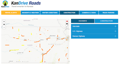
Numerous improvements have
been made to the Kansas Department of Transportation’s KanDrive website that
provides motorists continuously updated conditions of highways across the
state.
“The website received more
than 2 million views last winter,” said Alan Spicer, Assistant Bureau Chief in
Transportation Planning. “It’s important to keep the traveling public notified
of current and changing road conditions so they can make informed travel
decisions.”
The main page at www.KanDrive.org has
been streamlined to make it easier to begin viewing details. Just click on the
map to open the tabs at the top of the page, which have been expanded. The
first tab, Travel Alerts, gives a comprehensive list of incident closures, road
work closures and weather closures.
The other tabs allow motorists
to view several maps and include –
Incidents/weather –
shows road incidents, flooding, fog, blowing dust, law enforcement;
Winter conditions – this map becomes the main map on the website if any highways are affected by snow or ice;
Construction –
shows that are planned, active and have closed a section of highway. Also,
people can click on the map location for details on the project, and an
estimated start date has been added;
This information is also available
on mobile devices. A map icon has been added to the top of the mobile website
to assist users in opening the page.
“Helping
motorists receive a variety of information before beginning their journey will
give them the knowledge needed to plan their routes or even delay their start
time to when the situation improves,” Spicer said. “Being informed of road
conditions is an important tool to have when making travel choices.”


No comments:
Post a Comment